Leh Official site : http://leh.nic.in/
Road condition description : http://www.bikenomads.com/wiki/index.php/Leh#Road_status_2
Other links:
http://www.bikenomads.com/wiki/index.php/Leh
http://www.indiamike.com/india/ladakh-and-zanskar-f31/all-about-ladakh-t4912/6/
http://jayansr.blogspot.com/2007/05/riding-to-leh-this-summer.html
http://www3.utsidan.se/corax-e/routes/zmanleh.htm
http://www.outtheresomewhere.net/?page_id=90
http://www.tripadvisor.com/Travel-g297625-s5/Leh:India:Dining.Scene.html
http://www.bcmtouring.com/travel-guides/ladakh-travel-guide/manali-leh-travel-guide.html
| Day | From | To | Height | Distance | Time |
| 17 | Extra day... | ||||
| 18 | Manali | Mirhi (breakfast here...) | |||
| Mirhi | Rohtang pass | 3987m | 51 Km | ||
| Rohtang pass | Gramphu | 14 Km | |||
| Gramphu | Khosar | 5 Km | |||
| Khosar | Sissu | 16 Km | |||
| Sissu | Tandi (last fuel point) | 18 Km | |||
| Tandi | Kylong | 3350m | 11 Km |
| Total : | 115 Km |
| 19 | Kylong | Jispa | 25 Km | ||
| Jispa | Darcha | 7 Km | |||
| Darcha | Deepak Tal (lake) | 11 Km | |||
| Deepak Tal | Patseo | 3 Km | |||
| Patseo | Baralacha La | 4880m | 27 Km | ||
| Baralacha La | Serchu | 4253m | 36 Km |
| Total : | 109 Km |
| 20 | Serchu | Nakee La | 4903m | 43 Km | |
| Nakee La | Lachlang la | 5065m | 11 Km | ||
| Lachlang la | Pang | 4500m | 25 Km | ||
| Pang | Moore Start | 4752m | 7 Km | ||
| Moore plains | Moore plains end | 4660m | 40 Km | ||
| Moore plains | Taglang La | 5360m | 17 Km | ||
| Taglang La | Rumtse | 30 Km | |||
| Rumtse | Miru | 15 Km | |||
| Miru | Upshi | 3432m | 15 Km | ||
| Upshi | Karu | 14 Km | |||
| Karu | Thiksey | 18 Km | |||
| Thiksey | Choglamsar | 10 Km | |||
| Choglamsar | Leh | 3505m | 6 Km |
| Total : | 251 Km |
| 21 | Leh | ...sight seeing... | |||
| 22 | Leh | Chang La | 5288m | ||
| Chang La | Pangong Lake | 4419m | 150 Km | 9hrs | |
| Pangong Lake | Spangmik | ||||
| 23 | Pangong Lake | Leh | 150 Km |
| 24 | Leh | Khardung La | 5602m | 37 Km | |
| Khardung La | Khalsar | 3018m | |||
| Khalsar | Diskit | 3144m | |||
| Diskit | Hunder | 7 Km | |||
| 25 | Hunder | Leh | 3245m | 5-6hr | |
| 26 | Leh | ...extra day... |
| 27 | Leh | Nimu | 35 km | ||
| Nimu | Alchi | 10 Km | |||
| 28 | Alchi | Saspol | 10 Km | ||
| Saspol | Khalsi -> Lamayuru | 44 Km | |||
| Lamayuru | Mulbekh | 53 Km | |||
| Mulbekh | Kargil | 32 km |
| Total : | 184 Km |
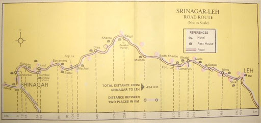
| 29 | Kargil | Drass | 62 Km | ||
| Drass | Zoji La ( timings...) | - | |||
| Zojilla Pass | Sonamarg | 56 Km | |||
| Sonamarg | Srinagar | 84 Km |
| Total : | 202 Km |
| 30 | Srinagar | ...sight seeing... | |||
| 31 | Srinagar | Udhampur | 172 Km | NH1a | |
| Udhampur | Pathankot (Punjab) | 139 Km |
Route : Manali - Rothang Pass - Keylong – Jispa - Darcha - Sarchu - Pang - Rumtse - Upshi - Karu – Leh : 475km
Day 18 Manali -> Kylong (115Km / 6Hrs) : Leave morning. Mirhi is a good place to have a breakfast of Aaloo parathas. The landscape changes once you cross Rohtang Pass. The road then drops to Gramphu and then splits, one going to Leh, the other going to Spiti Valley. Khosar has a few dhabas. Opposite Sissu look for a spectacular hanging waterfall. At Gondla see the ruins of a 7-storey 'thakur' fort dating back to 1700's. At Tandi, the road forks with one along Chenab river going towards Udaipur & Trilokinath temple 35km away. Kylong town is the capital of Lahul and Spiti. Visit Khardong Gompa.
Day 19 Kylong to Serchu (109Km) : Leave Keylong in the morning. Darch is a permanent settlement and is the start point for the trek to Padum in Zanskar. Dhabas offer basic food. Deepaktal is a nice place to camp & explore around. From Patseo it is a long winding climb up to Baralacha La and then a short descent down to Bharatpur City. Scenery changes dramatically as one crosses the Great Himalayan Range into the arid regions of Ladakh. Campsite at Serchu, situated on the banks of River Bhaga. It is cold & miserable at Sarchu.
Note : Tent camps at Sarchu are expensive, Bharatpur 30km from Sarchu for cheaper tents. Try 'Kathmandu Cafe'
Day 20 Serchu to Leh (251Km/9hrs) : Leave early morning, through Nakee La & Lachlang La through 20Km of Gator Loops (road coiling up the mountain). From the pass swoop down to Pang for lunch, then passing through Moore plains (biggest and highest Plateau on Earth stretching 40 Kms), Taglang La (2nd highest motorable road & 2nd highest temple in the world), reaching Upshi along a spectacular ravine. From here the dusty but well paved road follows the Indus river, passing villages. Reach Leh by evening.
Day 21 Leh : After breakfast, visit nine-storey Leh Palace and Shanti Stupa. Lunch & rest.
Leh Notes : carry a torch, warm clothes & sleeping bag.
“German Bakeries : best place to get some nice bread that´ll stay fresh at least two days, for the trek or bus.”
“Gezmo-german bakery on Fort rd is a good place to eat and to carry a packed lunch from them is a good idea. On your way to Pangong or Khadungla there are no places to eat, if your lucky you might find the tea stall open at the army camp where they serve some hot Maggie!”
“German Bakery - ironically run by a Sardar! Located in Leh Bazar. Baked products, - croissants, breads are quite good. When you're going on full day or overnight trips to other places, drop in to the bakery in the morning and pack up stuff for lunch. The yak cheese and bread roll are a great combination to munch at one of the numerous check points you encounter.”
“Web wallahs : lots of other internet places in Leh. These two places also had Photoshop,on their computers, and made CD´s from the camera.
Tashi´s Diner : great budget place, one of the few that stay open in the winter. Web wallah upstairs.
Dzomsa : Laundry services, safe pressure boiled water (BYO bottle), apricot juice (Mmmm... chuli chu), dried fruits for the trail and more.”
Day 22-23 Leh <-> Pangong Lake (150km/5-6 hrs one way) : Early morning B/F and leave for Pangong Tso through Changla Pass. This is third highest motorable road in the world. Pangong Lake is the highest salt water Lake in the world, 130Km long, and is shared by India & China. Enjoy the beauty of lake, blue & green in color with dun mountains in the backdrop capped with snow. Permit is only upto Spangmik 7km along south-western shore, do care to visit it for the view. No facilities here. Better to return back the same day or try accommodation at Tangtse. Back to Leh by same route.
Note : No petrol pumps on the way so get your tank filled up to cover 300+km
Day 24 Leh -> Khardung-la -> Khalsar -> Deskit -> Hunder : A trip to Nubra Valley which starts from Khalsar. Nubra means green, and it is also known as the valley of flowers. A permit is required, 20/- per day of stay per person, and it allows visit only up to Hudur & Panamik.
After breakfast drive to Nubra Valley via Khardung La (Highest Motorable road in the world, 18,380 ft) reach Hundur by afternoon, rest of the day free for exploring Deskit & Hundur Villages or one can leave for two hump camel safari in sand dunes at Hundur Village. Night stay at Hundur.
Note : One way traffic across Khardung La
morning traffic : Khardung La -> Nubra
afternoon traffic : Nubra -> Khardung La
Distances in Nubra Valley:
Diskit -> Hudur : 7Km (west side)
Diskit -> Sumur -> 38Km/1.5hrs (east side)
Sumur -> Chamshen : 6Km/30 minutes
Chamsen -> Panamik : 14Km/30 minutes . Hot springs at Panamik are believed to cure rheumatism and other ailments.
“one day, we made an hour long trip on the backs of bactrian camels (god, did they stink!) which took us from hundur to diskit and back after a visit to the impossibly-situated monastery (diskit gompa) perched on the top of a hill. the climb was well worth the effort - the views across the valley to where the shyok and siachen rivers meet were stunning. the journey past the glacier-fed indus on one side and the high Himalayas on the other was a memorable one.”
Day 25 Nubra Valley -> Leh : After breakfast proceed for Deskit Monastery and Drive back to Leh by same Route by crossing Khardungla Pass.
Day 26 Leh -> Alchi : Morning after breakfast leave for Alchi after Lunch Leave for Alchi Village. Visit to Alchi Gompa. And evening full at leisure in exploring the village of Alchi. “Magnetic hill (7km from nimmu towards leh, look out for mandir on left, works only for iron bikes!”
Day 27 Alchi ->Lamayuru->Kargil : After Breakfast leave for Lamayuru (Oldest Monastery on Central Ladakh Region) enroute where you can view a spectacular view Mountain Ranges and Moon landscape & Giant Maitreya Buddha on a way To Kargil at Mulbekh. Reach Kargil by evening.
Day 28 Kargil -> Srinagar (202Km) : Leave early in Morning for Srinagar by crossing Drass (2nd Coldest Inhabitant Place on earth), Zojila Pass, Where you have a Spectacular View of Kargil War Famous Peaks (Tiger, Tololing and Other Peaks), Sonamarg (Know as The Meadow of Gold), reach Srinagar by afternoon.
Notes :
1. Zoji La : Restrictions on traffic movement. Closed between 4pm to 4am, and fully closed once a week for maintenance. One way system for buses, Leh to Srinagar buses must cross the army post on top by 5am, so need to start by 1am from Kargil. If unlucky, you will be riding in the opposite direction to the trucks! Bad road for 20km on either side.
2. Leh -> Srinagar : 434km (NH1) : A total of 48 km is unaccounted for in the above distance chart between Leh to Srinagar.
3. Petrol pumps only at Khalsi & Kargil. No Petrol in Zanskar & Nubra valley.
Day 29 Srinagar :
Day 30 Srinagar -> Pathakot (311Km)
Day 31 Pathankot -> Ambala (281Km)
.JPG)
19 comments:
Hello, Sk
I loved this post and this blog.
Have a nice day.
thanks david!
Have a nice day...
Hi Sanjay....
Am interested in the June'08 trip. Have also sent an email at the yahoo group but didn't get any response so wondering, whats the status.
chao..
hi Prem,
nice of u to write. I have not made any postings on any yahoo groups so i dunno any thing about that. May be somebody set a link to my blog to use the trip details, which is what this blog is meant for anyway.
We are not on an organized trip please note. Just two persons on a single bike with plenty of time on hand, floating along that route with a very flexible time-table & destinations.
So i wonder if a bigger group will work out, as that will require more discipline & stricter itinerary. Let me know your thoughts & we can work out something perhaps...
Hey,
Well, your words say that you are a free bird. Well thats great.
Me and my wife are planning to go for this Leh horse shoe ride in June. We have an Avenger 180 and am hoping we shall be able to do it with her.
I have been reading a lot of threads on BCMT & BN & other blogs etc. And it seems, for the first time riders that we are on a single bike, the route to Leh via Srinagar is more suitable, as the max height during the reach is < 13500 ft. So that will help us get adjusted to the height and would reduce the chances for AMS.
But for our first long ride, We didn't want to do it alone and so I thought we shall do it along with other riders, preferably with some exp ones.We also had taken around 15 days in our schedule for Delhi-Leh-Delhi. So, just see how can it work out. If you it can, am open, else, that is still fine and may be we shall meet in Leh some place.
:-)
keep riding...
hi Prem,
ok, we plan to start out from Kullu on 5th or 6th June. So if we can meet up there, we can proceed together. I will make a post at http://sk-chik.blogspot.com with my contact email address. Please read & drop me a confirming mail. I will then delete that post.
But please understand that this is our first bike trip also, so don't count on company of two experienced guys! :) In fact i haven't ridden a bike for a few years now, just i have ridden enough at one time to be willing to take this trip.
Yes, this route is actually meant to be from Srinagar to Manali. In fact the Leh to Srinagar direction traffic though Zoji La pass needs to start at 1am to be able to cross the army post at top by 5am after which the traffic reverses. And then, since bikes are allowed, we will be going against the traffic in that worst sector of the route. This is one through that is giving me a lot of headache. But since we are going on a trek in Kullu region in May end, it is just convenient for us to carry on from there to Leh.
Acclimatization wise, we will be doing 3350m at Kylong, then 4253m which will be problematic for sure, and then 3505 at Leh which will be right nice to be down to that height. I wonder where u can spend one more night at around 3500m, that would be very useful for acclimatization.
For us, we will already have trekked the following heights in the preceding week : 2438m, 2896m, 3353m, 3810m, touching 4206 & going down to 3353 & then down. So we will be much acclimatized when we start for Leh.
Re acclimatization : Keylong is actually below 3100 , both from gps logs and Google Earth.Glad to hear yo have some time around 3000 before , would definitely try get a intermediate stop before Sarchu anyway.
Darcha is just over 3400. Sifting out real altitudes is worth some work , there is a lot of bad info out there - I did an edit on the Wikipedia Sarchu article for example , raising the altitude with 500 meters to 4253/4290.
yes, the details of altitudes are quite varied. I picked a median kind of value from all the values are found here & there.
Mostly people are making noting from the altimeter watch which rely on barometer reading for altitude calculations. So a low pressure in Calcutta would make it below sea level according to such watches! I don't think there has been any real reading done with a proper altimeter equipment.
made a slip there... actually a high pressure (instead of low pressure) might make those watches report Kolkata below...
My instincts on altimeters are the same .. but reading Corax log I was surprised to see that the difference between altimeter and gps was at most just under 100 meters , and mostly well below that.
Looking up Tabo as an example , it´s easy to see that the altitude is 3050 meters . Lots of sources confirm this , the official nic.in page , notations on Google Earth, numerous other sites . the only one disagreeing is reality : looking at the actual marker on GE , buildings easily seen , the altitude is 3265 .. same as on the road sign.This is also the altitude given on masterlyinactivity.com , who used altimeters and cross checked them with gps occasionally .
I´m starting to ask myself now if I have any point - I guess it would be that the technical solutions are better than we think, and that we humans err, often , when applying them.
Hey...
Can you believe it, I had lost track of your blog and couldn't agther for all these days. Daily I used to search for it.
And, yes you were correct, I actually had mistaken and confused your trip with a yahoo groups trip to Leh.
Anyways, I shall drop you an email.
cheers...
And infact, I found it today. Bookmarked correctly but in the wrong folder, so I was missing it.
:-)
Thanks
@vistet
yeah, no point splitting hairs. A hundred meters here or there would not really matter in terms of temperature or air density in the normal run.
I think the wide variance comes for the inability to operate the instruments. For example in the Casio Altimeter watch I think u can set the base altitude, and then it shows the heights gained or lost from there on. So if u set it at zero at Sarchu, it should show -4253m at sea level.
Hey ... awesome blog! We were actually planning on a visit in June end.. but you seem to have a great plan here so we might think of June beginning too. I was planning to go with a couple of my friends from bangalore to manali and hence forwards. I would appreciate it if you could tell me how much the expenses you came up are and if there is a possibility of renting a bike for the trip once we reach there ?
hi bikergoddess, thanks!
expenses part i haven't seriously worked out yet. Will try to work out next week before i leave on the trip.
Here is an idea :
Petrol : 100 Ltrs for Manali to Srinagar complete circuit including site seeings.
Manali->Leh->Srinagar : 475km+434Km= 909Km
Leh<->Pangong Lake : 300Km
Leh <->Hundur : 88km
----------------------------------------------
Total : 1297Km * 150% = 1945Km/20km per ltr=97 ltrs
Daily expenses can be estimated at 500/- per day as a rough guide.
I will try work out a more concrete estimate next week.
If u have a bike, better to bring it by rail to Chandigarh & then ride to Manali. I heard the bikes on rental are not so reliable.
I am keeping my fingers crossed for the 1st week of June schedule. The news till now is that the road should be fully functional by then. Winter has been short this year.
hi Prem...awaiting your confirmation...
Hey Sanjay....
What are the exact dates , that you are leaving from Kullu/Manali for Leh.
Mine is to leave Delhi on 14th and Manali or Marhi on 16th morning.
Sorry, for not keeping in touch, had loads on the head.
Mail me at premaror@gmail.com.
I missed your emailID.
cheers..
-prem
Post a Comment